Danish postcards in the Polish intelligence service
The discovery of Danish postcards in Polish intelligence from the Cold War raises questions about what considerations Denmark made regarding the sale of critical infrastructure photographs.
Users of Royal Danish Library's online collections may be familiar with the website "An Aerial View of Denmark". Here, volunteers have helped place more than 2 million historical aerial photographs on the map of Denmark. The images originate from various aerial photography companies, which typically made money by selling aerial photos to, among others, homeowners and farm owners, but also sold aerial photos as postcards. As a result, one often finds postcards featuring aerial views of towns, harbours, and buildings, which were sold to tourists and locals from the photographed areas - and, as it later turned out, to Polish intelligence officers.
An Aerial View of Denmark
Royal Danish Library's aerial photography collection currently contains 5.2 million images from the period 1936-1992.
In connection with the research project "Poland and Denmark - Enemies During the Cold War" on Polish military planning against Denmark, employees at Langelandsfortet reviewed a large amount of materials from the Polish naval archive in Gdynia. The material consisted of documents and photo albums from the Cold War. It showed that Polish intelligence personnel had travelled around Denmark while planning a potential offensive in the event of war.
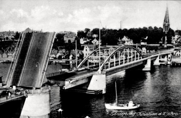
Photo: Rudolf Olsen Kunstforlag (-1994)
That account in itself provides a fascinating insight into the Cold War landscape of the 1960s and 1970s, but the documents also told another interesting story. It quickly became clear that ordinary postcards were used as visual material in Polish intelligence on Denmark. Danish postcards featuring motifs of critical infrastructure, such as bridges and harbours, had therefore been produced and subsequently sold in kiosks, bookshops, and grocery shops, apparently without consideration of whether, in the wrong hands, they could pose a risk to national security.
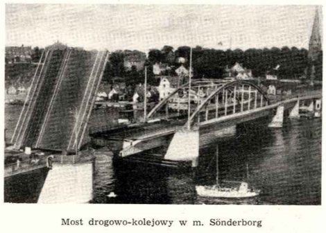
Photo: Den Polske Generalstab.
Employees from Royal Danish Library quickly found an example of a postcard that existed both in the Polish intelligence material and in the postcard collection: A postcard of King Christian X's Bridge (between Sønderborg and Jutland), which in 1969 had been used in a secret Polish description of the Jutland infrastructure.
Library staff compared several images from the naval archive in Gdynia with postcards in the postcard collection, and subsequently searched for the motifs as aerial photographs in ‘An Areal View of Denmark.' Here, they succeeded in finding at least one example of a motif that appears across all three collections: in one of the folders from the naval archive, a group of Polish agents in 1971 documented their journey around Zealand with a combination of typewritten notes and images. Some of these were taken by the intelligence officers themselves, while others quickly turned out to be ordinary postcards.
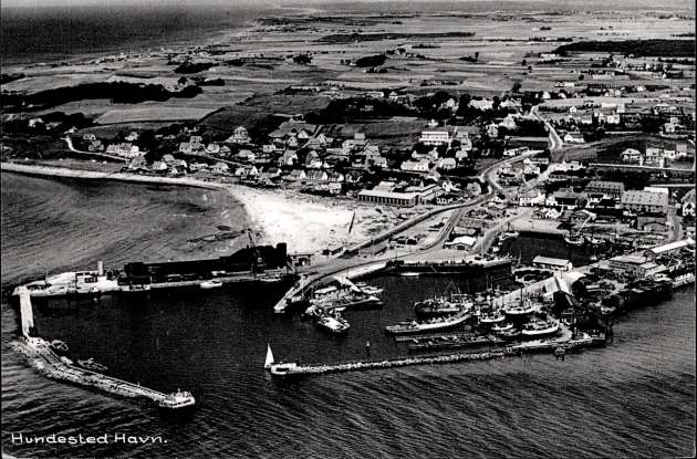
One of these pictures shows a ferry in the harbour of Hundested. That motif was quickly identified as a postcard in the library's own postcard collection and, upon closer examination, was subsequently found as an almost identical photograph in "An Areal View of Denmark" from around 1970. It was concluded that the aerial photograph and the postcard motif must have been taken on the very same day, just a few minutes apart.


The discovery raises some interesting questions about the security considerations that were made (or not made) in connection with the production of aerial photographs and postcards in Denmark during the Cold War. It is difficult to imagine that there would have been much enthusiasm within the Danish military and government at the thought that hostile powers could simply walk into a local kiosk in Hundested and purchase pictures of local infrastructure for use in planning a landing operation in the event of war.
This did not, however, lead to a ban on the private sale of aerial photographs. The discovery thus underlines the Danish commitment to a democratic and open society, even during the Cold War. Whereas in the Eastern Bloc there was extreme caution regarding which information was publicly accessible, in Denmark it was too easy to obtain significant infrastructural information through, for example, newspapers and public libraries – and, indeed, through postcards.
Royal Danish Library's Postcard Collection
It is unknown when the topographical postcard collection was established, but the Picture Collection can be dated to 1902. The topographical postcard collection consists of approximately 310,000 postcards which have been delivered, purchased or donated; and that either have a photographic or illustrated motif.
The postcards primarily cover the period from around 1905 to 1950, although both earlier and later examples also occur. The photographers are often unknown – in such cases, for example, the publisher or bookshop is indicated as the originator. The postcards are either dated on the basis of stamps from the printer, publisher, or Royal Danish Library, the sender’s date, or the card’s postmark. As a result, the date is given as an approximation.
Please note whether a postcard is free of copyright if you wish to use it for purposes other than private use.