An Aerial View of Denmark
See our digitised aerial photos from our extensive collection. You can also help us place them on the map of Denmark.
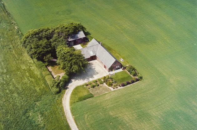
Photo: Sylvest Jensen Luftfoto
Search directly in An Aerial View of Denmark
Press the button to visit An Aerial View of Denmark. You search by zooming in on the area on the map you are interested in viewing aerial photos from.
How to find an aerial photo
You must use the map in An Aerial View of Denmark to zoom in on the area you are interested in finding aerial photos from. The search function only works within the area you have zoomed in on. Try zooming out if you do not get any results on your searches.
Get started
About An Aerial View of Denmark
An Aerial View of Denmark - you can see old aerial photos of Denmark from 1890 onwards from long before Google Maps was an online service.
Royal Danish Library's collection of aerial photographs consists of around three million unique recordings from 1890 to 2010. The collection provides an extraordinary insight into the development of the cultural landscape and infrastructure in the cities as well as in the countryside through the 20th century.
The service aims to give new (digital) life to old aerial photos and make them freely accessible to everyone. Since the beginning of the project, the public has been involved in the work of placing the images on the map of Denmark, as there is no information in the archives about the exact locations of the images. It is therefore possible for users who are logged into the service to move the images to the correct location on the map of Denmark. Users get points based on how many images they have helped place.
If you would like to know more about the project An Aerial View of Denmark - before Google, please contact us with your questions.
How to place aerial photos
How to place aerial photos on the map of Denmark:
1. Register as a user
If you are not already registered as a user at Royal Danish Library or have not been logged in after 19 November 2019, you must register online by clicking on Login in the upper right corner of the screen on An Aerial View of Denmark. Here you have to select NEM ID (private users) and follow the instructions on the screen. Login ID and PIN code for loans is only important if you also need to borrow books from Royal Danish Library.
After you have first logged in using NEM ID and registered your e-mail address and created a password, you can log in using only your e-mail address and self-selected password in the future. If you experience problems with your online registration, you can contact us.
2. Zoom in on the area you want to work on
First select the part of Denmark you want to work with in the drop-down menu Select area. Once you have selected a region, you can zoom in on the local area you are interested in. Each zoom has its own URL that you can bookmark. Each time you zoom in, you limit the number of displayed images. For example, if you only want to see photos of a single property, simply zoom in on the property.
Green markers show aerial photos that are positioned correctly. Red markers show aerial photos that have not yet been placed correctly. Blue markers show aerial photos no one has yet been able to place despite countless attempts. Orange markers show protocol pages.
3. Find a photo you can place
Once you have zoomed in on the area you want to work with, you can see all the photos from the area on the left side of the screen. If you only want to see photos that have not yet been placed (red markers), click on the gear wheel to the left of the search field, and in the unfolding menu, select Not correctly placed in the Location field. Once you have found a photo that you can place, click on the image to go to its landing page. Here you can place the photo and edit its information.
4. Correct or add information
All information in the fields Title, Person, Building name, Note and the address can be corrected. Just enter the information in the fields, check the square box in front of You must accept Royal Danish Library's Rules, and then click the floppy disk icon just above. All information you add or correct in these fields is searchable and can be corrected by other users.
If you do not already know the exact address, you can find it in Google Maps by zooming in on the property, right-clicking on it and selecting What's Here? The more information you correct and/or add, the better An Aerial View of Denmark will become.
5. Comments
Information you add as a Comment is not searchable. A comment cannot be deleted by other users, but only by the user who added it. If you want to delete a comment you have added yourself, click on the small green x next to your username above the comment.
6. Work with one series at a time
All photos in a series are, with a few exceptions, basically taken in the same area and are connected (flight route). Because of this, working with one series at a time is most optimal. The IDs of the photos are based on the original numbers for the negatives and are composed of a serial name and a serial number. If you want to search for one specific series or one specific image in a series, you can search in the free text search field in An Aerial View of Denmark.
For example, if you have placed the image AAL_BL45-145_001, you can search AAL_BL45-145 in the free text search field to find the remaining images in the series. Now click on the small arrow next to No sorting (the field just below the free text search field) and select File name ascending for example - now you get the whole series in the order the photos were (probably) taken, and if you have placed AAL_BL45-145_001 first, AAL_BL45-145_002 will likely be one of the neighbouring properties.
7. Use the orthographic maps and the topographic maps
Farm names and other information about the individual photos are taken from either the protocols of Sylvest Jensen Luftfoto or from the back of the sample photos, so there may be errors! Therefore, do not blindly rely on a given farm or property owner name, but instead use the orthographic maps to find the correct location of the image. The orthographic and topographical maps can be found in the menu Load maps of An Aerial View of Denmark. Only a few properties have retained the same appearance from the mid-1950s to today, so if you want to place a photo from 1955, for example, you can use the orthographic map from 1954, where you can see the whole of Denmark. If you want to find an older property or farm name, you can use the topographic maps.
Download an aerial photo
Can I download a photo?
You can. Click on the photo you want to download until you reach the photo's landing page. Click on the download icon on the far left of the photo and it will open on a new page. Place the cursor on the photo, right-click and select Save image as…
Purchasing an aerial photo
Can I purchase a high-resolution scan or a printed copy of an aerial photo?
You can find and download aerial photos in high resolution from An Aerial View of Denmark. We can also do it for you for a fee.
We also offer printing of previously digitised aerial photos on photo paper.
Find information about price and booking (look under the item Especially about aerial photos).
Publishing and sharing
Can I use aerial photos on my website or print them in an article or book?
You may. All aerial photos from An Aerial View of Denmark may be used freely when crediting Royal Danish Library and the photographer - for example: Sylvest Jensen Luftfoto; Royal Danish Library.
May I edit a photo I want to publish?
Feel free to change the contrast or lighting, as long as it does not change the image itself. You are also welcome to remove any sample stamps and notes written with a ballpoint pen, as this is something that was applied later and not part of the original image. We can not, however, give you permission to remove cars, buildings, people or anything else that is part of the original image.
Other questions
Where can I read more about Royal Danish Library's Aerial Photograph Collection?
You can read more about our collection.
How many aerial photos have been digitised?
You can see the answer under Statistics.
Why are there no aerial photos from my local area?
There can be three explanations for this:
- Aerial photos from your area have not yet been digitised.
- Aerial photos have been digitised but have not yet been placed correctly.
- There are no aerial photos from the area in question in the aerial photograph collection. We encourage everyone who has knowledge of historical aerial photograph collections to contact us.
Are there protocol pages for all aerial photos?
No, there are only protocol pages for the series that come from Sylvest Jensen Luftfoto. Sylvest Jensen kept a careful record of the aerial photos that the company took and sold. For each roll of film, a neat protocol page was kept that could tell where and in what year the photograph was taken and to whom it was possibly sold.
How do I search a protocol page for an aerial photo?
All aerial photos have an ID, which can look like the following example: ID L0822_34.tif. If you search for the first part of the number (in this case: L0822) in the search field, you will find all aerial photos and the protocol page for that series. All protocol pages have an _i_ in the file name. If you only want to find the protocol page, then search for L0822_i_.
More information
Partners
An Aerial View of Denmark would not have happened but for the support from:
- The Ministry of Culture, which financed the development of the portal as well as digitisation of aerial photos from Funen and surrounding islands through a significant grant from the UMTS pool in 2010
- Bornholm's Regional Municipality, which in 2013 contributed to the digitisation of aerial photos from Bornholm and Christiansø
- The Danish Agency for Culture and Palaces, the Museum Council in Ringkøbing County, Ringkøbing-Skjern Municipality, Holstebro Municipality, Skive Municipality, Ikast-Brande Municipality, Lemvig Municipality, Struer Municipality and Herning Municipality, which in 2014 financed the digitisation of aerial photos from the seven municipalities in the western part of Central Jutland
- Aage and Johanne Louis-Hansen's Foundation, which, with a significant donation in 2015, has financed the digitisation of Zealand including the metropolitan area, Lolland-Falster and surrounding islands
Royal Danish Library thanks everyone for their contribution to the digitisation and communication of a unique part of the Danish cultural heritage.